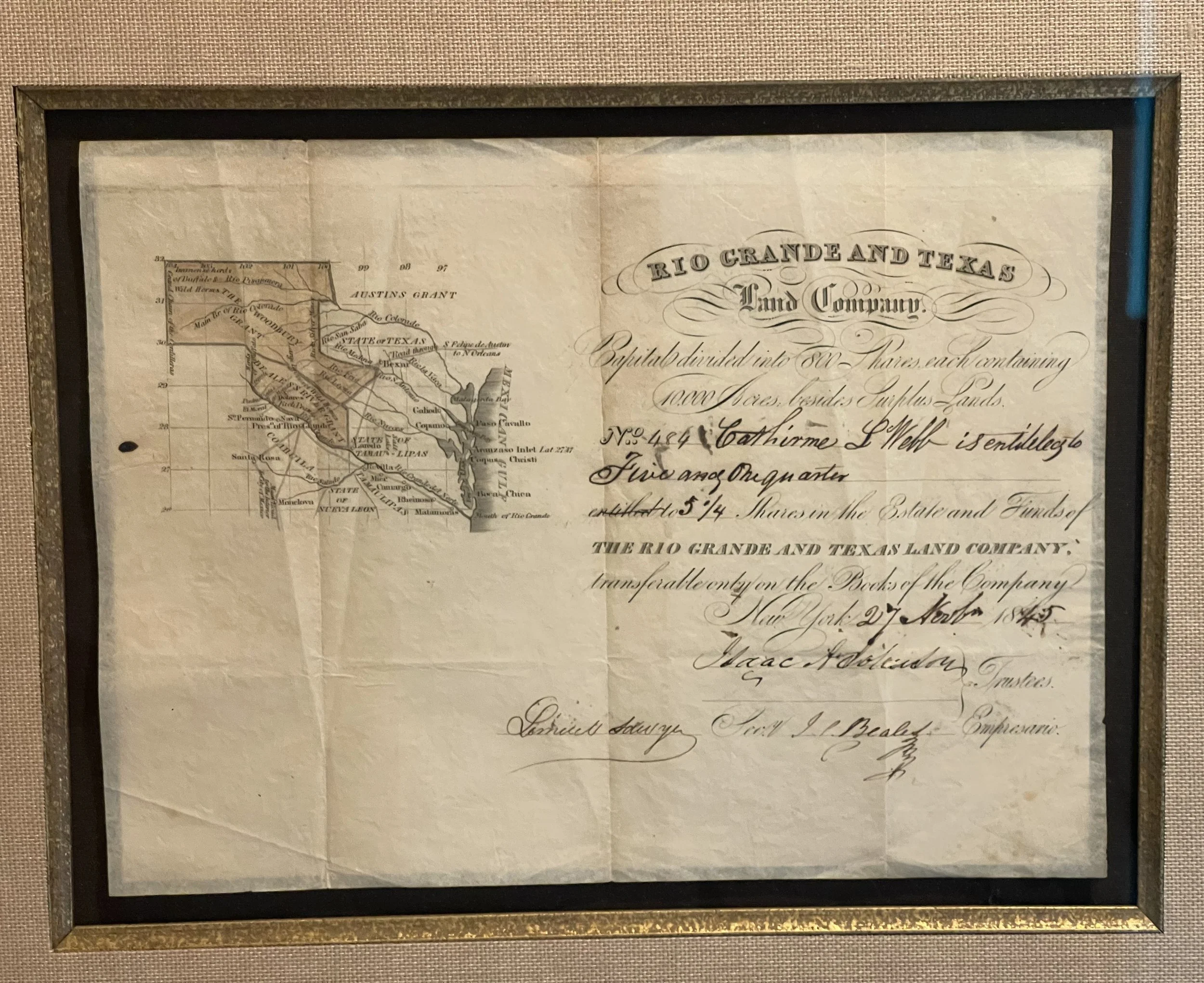
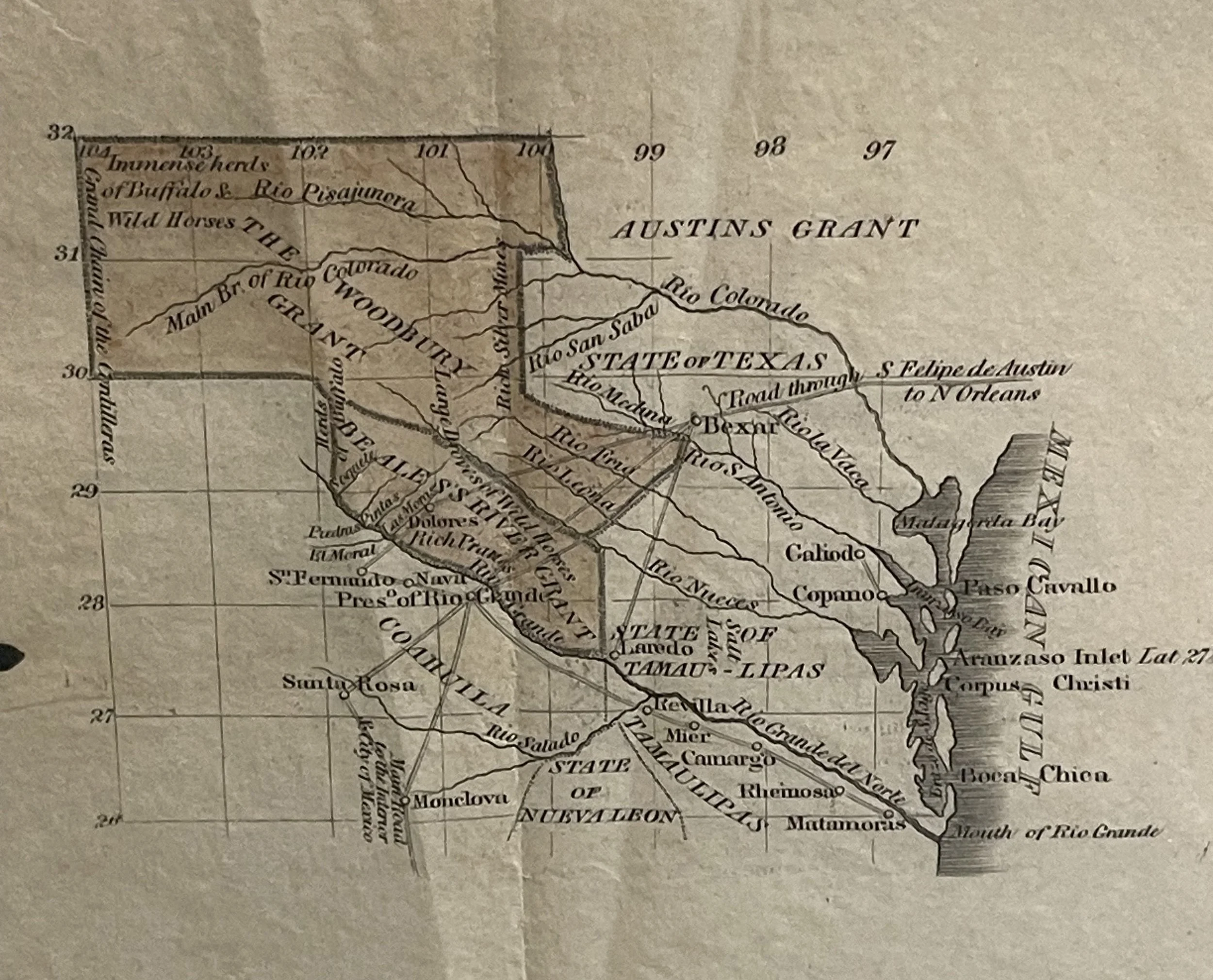
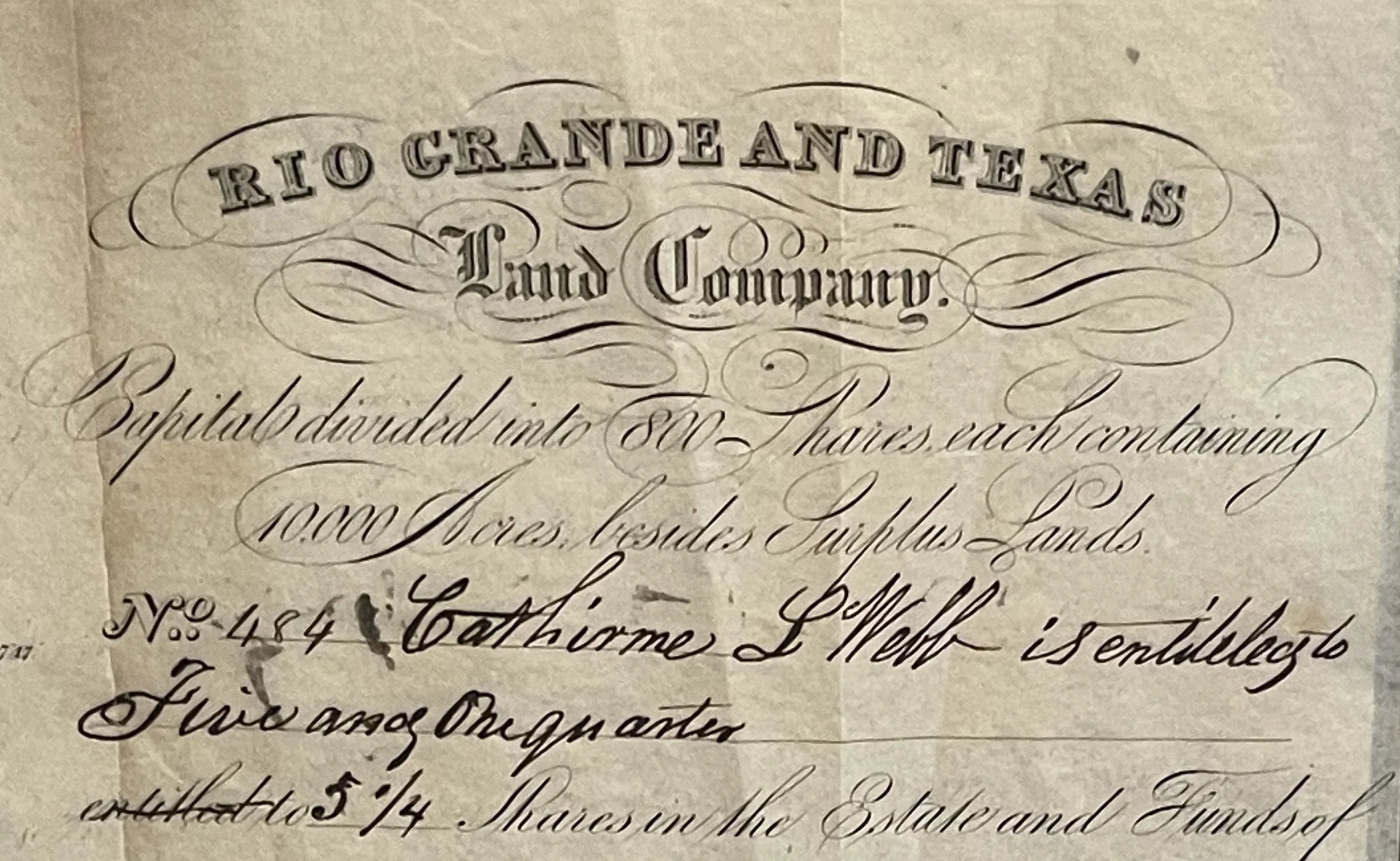
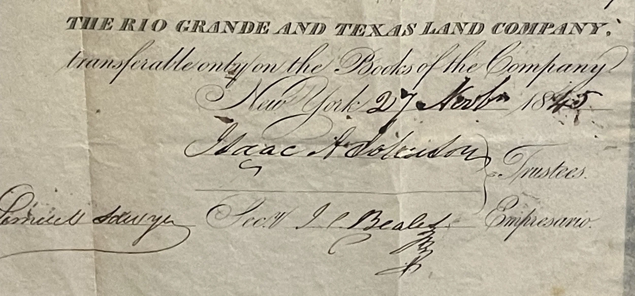
Skip to Content
Buffalo Antiques Texas
Shop
About
Contact
0
0
Buffalo Antiques Texas
Shop
About
Contact
0
0
Shop
About
Contact
Shop 1853 Map U.S. Coastal Survey of Sabine Pass, TX
IMG_0495.JPG Image 1 of 9
IMG_0495.JPG
SabinePass_close.jpg Image 2 of 9
SabinePass_close.jpg
SabinePass_close_title.jpg Image 3 of 9
SabinePass_close_title.jpg
SabinePass_close_description.jpg Image 4 of 9
SabinePass_close_description.jpg
IMG_0496.JPG Image 5 of 9
IMG_0496.JPG
IMG_9668.JPG Image 6 of 9
IMG_9668.JPG
IMG_9680.JPG Image 7 of 9
IMG_9680.JPG
IMG_9671.JPG Image 8 of 9
IMG_9671.JPG
IMG_9672.JPG Image 9 of 9
IMG_9672.JPG
IMG_0495.JPG
SabinePass_close.jpg
SabinePass_close_title.jpg
SabinePass_close_description.jpg
IMG_0496.JPG
IMG_9668.JPG
IMG_9680.JPG
IMG_9671.JPG
IMG_9672.JPG

1853 Map U.S. Coastal Survey of Sabine Pass, TX

$160.00
DESCRIPTION

This antique map of Sabine Pass from 1853 shows its age through the deep tones of its paper, with faint lines of old folds and the marks of the sun.

Marked as Plate 38; Sketch I, No.2, US Coast Survey by the Hydrographic Party under the command of Lt. J. Wilkinson, U.S.N. Assist., this map immortalizes the state of the Gulf Coast not even ten years after Texas became a state.

Find history & context below.

DETAILS & MEASUREMENTS
  • Measures 11.5" width x 15" height

  • Toned map with sun-aged paper, sun-bleached square on left -

  • Vintage frame has light scratches

  • Dated 1853

  • Map from reconnaissance of Sabine Pass

  • Plate 38; Sketch I, No.2, US Coast Survey by the Hydrographic Party under the command of Lt. J. Wilkinson, U.S.N. Assist.

  • Light fold lines, one larger horizontal fold

Add To Cart
DESCRIPTION

This antique map of Sabine Pass from 1853 shows its age through the deep tones of its paper, with faint lines of old folds and the marks of the sun.

Marked as Plate 38; Sketch I, No.2, US Coast Survey by the Hydrographic Party under the command of Lt. J. Wilkinson, U.S.N. Assist., this map immortalizes the state of the Gulf Coast not even ten years after Texas became a state.

Find history & context below.

DETAILS & MEASUREMENTS
  • Measures 11.5" width x 15" height

  • Toned map with sun-aged paper, sun-bleached square on left -

  • Vintage frame has light scratches

  • Dated 1853

  • Map from reconnaissance of Sabine Pass

  • Plate 38; Sketch I, No.2, US Coast Survey by the Hydrographic Party under the command of Lt. J. Wilkinson, U.S.N. Assist.

  • Light fold lines, one larger horizontal fold


➼ History & Context

Fewer than 10 years after Texas became a state, the US initiated coastal surveys of the lands along the Gulf of Mexico. Amongst other things, the United States Army Corps of Engineers was looking for harbors that could be used or deepened to create a deepwater port for the region.

The town of Sabine Pass, initially known as Sabine City, began around 1836. It was organized by the Sabine City Company, which included such figures as Sam Houston, Albert G. Kellogg, and Sidney Sherman. Jefferson County’s first steam-powered sawmill was built there in 1846, and in 1847 their first post office was established. So when the Army came to town to begin their survey of the coastal conditions in 1853, the nascent town was really beginning to hustle and bustle.

You Might Also Enjoy

close.jpg close.jpg close.jpg close.jpg close.jpg close.jpg close.jpg close.jpg close.jpg close.jpg close.jpg close.jpg close.jpg close.jpg close.jpg close.jpg close.jpg close.jpg close.jpg close.jpg close.jpg close.jpg close.jpg close.jpg close.jpg close.jpg close.jpg close.jpg close.jpg close.jpg close.jpg
Pictorial Wall Map of the United States c. 1853
$3,800.00
IMG_9649.JPG IMG_9649.JPG IMG_9649.JPG IMG_9649.JPG IMG_9649.JPG IMG_9649.JPG IMG_9649.JPG IMG_9649.JPG
1853 Map U.S. Coastal Survey of Aransas Pass, TX
$160.00
sold out
IMG_0454 2.JPG IMG_0454 2.JPG IMG_0454 2.JPG IMG_0454 2.JPG IMG_0454 2.JPG IMG_0454 2.JPG IMG_0454 2.JPG IMG_0454 2.JPG IMG_0454 2.JPG IMG_0454 2.JPG
1856 Map of the Texas Sea Coast Near Galveston
$800.00
IMG_5528.JPG IMG_5528.JPG IMG_5528.JPG IMG_5528.JPG IMG_5528.JPG IMG_5528.JPG IMG_5528.JPG IMG_5528.JPG IMG_5528.JPG IMG_5528.JPG IMG_5528.JPG IMG_5528.JPG IMG_5528.JPG
Framed 1845 Republic of Texas Map
$1,900.00

Buffalo Antiques

Shop

About

Contact

FAQs


Join Our Community

Get news of new items to the shop and upcoming events

*We won’t spam your inbox, and we’ll never share your information.

Thank you! Keep an eye out for your confirmation email.